Difference between revisions of "Hitchgathering/2024"
(Tags: Mobile edit, Mobile web edit) |
(→Main Hitchgathering) |
||
| (17 intermediate revisions by 5 users not shown) | |||
| Line 1: | Line 1: | ||
| − | + | The (European) Hitchgathering is happening every year in the first two weeks of August at a different location. | |
| + | For general info check: [[Hitchgathering]] | ||
| − | + | =Communication= | |
| − | + | * Main organisation platform is this wiki page. Here you can collect/present proposals and use the [[Talk:Hitchgathering/2024|talk page]] | |
| − | [[ | + | * Other communication channels are the [https://lists.riseup.net/www/subscribe/hitch mailing list], [https://signal.group/#CjQKIGgw5-FMZ1Sq67CL50LKCkZg-6i0KCDuS24S4uBDyb5IEhAmnOqOcim9eSMm-TJFozyg Signal-group] and the [https://www.facebook.com/groups/hitchgathering/ Facebook group]. Please transfer all relevant info to the wiki page. |
| − | 46.32708, 12.73115 | + | =Main Hitchgathering= |
| + | [[Hitchgathering/2024/vote|direct link for the voting]] | ||
| + | ==proposals== | ||
| + | ===Malga Chiampis, Italy=== | ||
| + | [[File:Casera Champis location.png|right|300px|Regional map]] | ||
| + | |||
| + | The valley at Malga/ Casera Chiampis: | ||
| + | |||
| + | [[File:Screenshot Maps.png|300px]] | ||
| + | |||
| + | location: [https://www.openstreetmap.org/#map=19/46.32707/12.73085 46.32708, 12.73115] | ||
Malga Chiampis is a bivac hut. i don't suggest to have the gathering in the hut, but in the huge valley floor around it. | Malga Chiampis is a bivac hut. i don't suggest to have the gathering in the hut, but in the huge valley floor around it. | ||
in 2018 a thousand rainbow people gathered there, it's a huge open area at 1200m ASL, surrounded by peaks just shy of 2000m ASL. the place is about 5hours hike from the road, hiking trail begins close to Tramonti di Sopra. there should be drinking water, else the rainbow gathering would not have been possible. | in 2018 a thousand rainbow people gathered there, it's a huge open area at 1200m ASL, surrounded by peaks just shy of 2000m ASL. the place is about 5hours hike from the road, hiking trail begins close to Tramonti di Sopra. there should be drinking water, else the rainbow gathering would not have been possible. | ||
| + | === Pre Alpi Carniche, Italy=== | ||
| + | location: [https://www.openstreetmap.org/?mlat=46.4012&mlon=12.9005#map=14/46.4012/12.9006 46.4012, 12.9005] | ||
| − | + | Not too far from the one above | |
| − | [[File:Quinis3.png]] | + | |
| + | [[File:Quinis3.png|thumb|Zoomed in map]] | ||
This exact spot (pin on the map) is mostly a steep hill. A vehicular dirt path runs just south of the pin, across it is plenty of brambley, flat, muddy areas. Local people do come around this area. | This exact spot (pin on the map) is mostly a steep hill. A vehicular dirt path runs just south of the pin, across it is plenty of brambley, flat, muddy areas. Local people do come around this area. | ||
| Line 19: | Line 33: | ||
# Following a dirt path across an open field/ pasture, then passing through a row of trees and bushes; | # Following a dirt path across an open field/ pasture, then passing through a row of trees and bushes; | ||
# then crossing a dry river bed. The river bed is accessed from a well-used dirt ramp for offroad vehicles. The bed of the Tagliamento River itself is mostly pebbles and hikable. East of/ at the confluence "Degano" there is clean river water that is drinkable. From the vehicular bridge at Invillino, the water is no higher than knee height. Water levels might be lower in the summer, otherwise and probably good for bathing. River levels: https://earlyfloodalert.com/paw/index.html?commonid=friaul-540-it | # then crossing a dry river bed. The river bed is accessed from a well-used dirt ramp for offroad vehicles. The bed of the Tagliamento River itself is mostly pebbles and hikable. East of/ at the confluence "Degano" there is clean river water that is drinkable. From the vehicular bridge at Invillino, the water is no higher than knee height. Water levels might be lower in the summer, otherwise and probably good for bathing. River levels: https://earlyfloodalert.com/paw/index.html?commonid=friaul-540-it | ||
| − | #There is another vehicular dirt ramp on the other side adjacent to an inhabited house. Next to that is a pasture that is cordoned off. Following the dirt path and turning right, the spot is just past another inhabited hut on the right hand side. | + | #There is another vehicular dirt ramp on the other side adjacent to an inhabited house. Next to that is a pasture that is cordoned off. There is a constantly flowing tap directly next to the dirt path across from the building. Following the dirt path and turning right, the spot is just past another inhabited hut on the right hand side. |
At Invillino, there is a Euro Spar supermarket with super easy dumpsters. https://gopro.com/v/Bb6QmKEvLQoO9 | At Invillino, there is a Euro Spar supermarket with super easy dumpsters. https://gopro.com/v/Bb6QmKEvLQoO9 | ||
| Line 28: | Line 42: | ||
Scouting pics and videos https://gopro.com/v/zbMEae30d1eBd | Scouting pics and videos https://gopro.com/v/zbMEae30d1eBd | ||
| + | |||
| + | ===Sacuieu, Romania=== | ||
| + | Locaton of 2015 European Rainbow Gathering. Săcuieu. (In Hungarian: Székelyjó), in the Apuseni mountains. | ||
| + | |||
| + | Go westbound along Highway 1 (E60) towards Oradea. Drive for 62km until you reach Bologa, then head south along 103H and go another 12.8km through Sacuieu until you see a sign “Pensiunea Sequoia” - then turn off from the main road onto a dirt road to a place (a hostel). Continue driving past for another 500m approx. towards the river. You’ll then find the Rainbow car park. The walk-in is about 40 minutes. | ||
| + | |||
| + | ===Gura Apelor, Romania=== | ||
| + | Dear Sibs, Kins, Mothers, Brothers, and Others, | ||
| + | |||
| + | the Romanian scouting team has returned from their mission. They have braved heat and snow, rock slides and bears, Țuică and psychoactive chocolate disasters. They have hitched with trucks and buses, amateur race drivers and beer salesmen, priests and conspiracy theorists. They have stolen boats, crossed raging mountain torrents and emptied countless jars of Zacuscă. In short, they have left no rock unturned and now bring to you: The prospective location of the 2024 European Hitchgathering! *drum roll* | ||
| + | |||
| + | Gura Apelor, the Mouth of the Waters, is a reservoir lake high up in the mountains of Hunedoara. https://www.openstreetmap.org/#map=18/45.33274/22.72267 It was actually suggested to us by our first ride in Romania... and it was a good suggestion! The lake is some 20-25 kilometers from the nearest village, located right outside the confines of Retezat national park. On a random Thursday in April, we saw a couple of other cars up there, which suggests that in August it should be possible to catch a ride up there every once in a while, while not being overly crowded. The camp site consists of a large flat grassy meadow (there would be space for at least 100 people to camp) near the lake. The Romanian state hydroelectric company has a security guard posted on the other end of the lake (quite out of sight from the campsite), near the beginning of the dam, who said something along the lines of "it's not allowed to camp there, but people do it anyway." The people who recommended the place said that in summer hikers sometimes camp there before going up into the national park. There is a water source available (other than the lake). In case the place should turn out to be too crowded or there should be some sort of legal issue, there is an alternative a couple of kilometers down the road: A meadow completely sheltered behind trees, accessible via an old footbridge (somewhere around here: https://www.openstreetmap.org/#map=17/45.34938/22.74280) | ||
| + | |||
| + | The downsides seem to be 1) that it's hard to say how many other people will be there in August -- it is a public space, if much out of people's usual way -- an 2) that the nearest confirmed dumpster is in Timisoara ;-) | ||
| + | |||
| + | ==voting== | ||
| + | please vote here for the location of the hitchgathering: [[Hitchgathering/2024/vote]] | ||
| + | |||
| + | ==social media== | ||
| + | Reddit: https://www.reddit.com/r/hitchhiking/comments/1ceasbu/european_hitchgathering_2024_location_is_up_for/ | ||
| + | |||
| + | Facebook: | ||
| + | https://www.facebook.com/events/1565424710695561 | ||
| + | |||
| + | =pre-/post- and other gatherings= | ||
Latest revision as of 11:55, 27 April 2024
The (European) Hitchgathering is happening every year in the first two weeks of August at a different location. For general info check: Hitchgathering
Contents
Communication
- Main organisation platform is this wiki page. Here you can collect/present proposals and use the talk page
- Other communication channels are the mailing list, Signal-group and the Facebook group. Please transfer all relevant info to the wiki page.
Main Hitchgathering
proposals
Malga Chiampis, Italy
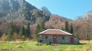
The valley at Malga/ Casera Chiampis:
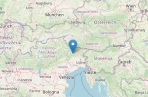
location: 46.32708, 12.73115
Malga Chiampis is a bivac hut. i don't suggest to have the gathering in the hut, but in the huge valley floor around it. in 2018 a thousand rainbow people gathered there, it's a huge open area at 1200m ASL, surrounded by peaks just shy of 2000m ASL. the place is about 5hours hike from the road, hiking trail begins close to Tramonti di Sopra. there should be drinking water, else the rainbow gathering would not have been possible.
Pre Alpi Carniche, Italy
location: 46.4012, 12.9005
Not too far from the one above
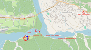
This exact spot (pin on the map) is mostly a steep hill. A vehicular dirt path runs just south of the pin, across it is plenty of brambley, flat, muddy areas. Local people do come around this area.
The pin is about a 20-30 minute hike from the road (SS52).
- Following a dirt path across an open field/ pasture, then passing through a row of trees and bushes;
- then crossing a dry river bed. The river bed is accessed from a well-used dirt ramp for offroad vehicles. The bed of the Tagliamento River itself is mostly pebbles and hikable. East of/ at the confluence "Degano" there is clean river water that is drinkable. From the vehicular bridge at Invillino, the water is no higher than knee height. Water levels might be lower in the summer, otherwise and probably good for bathing. River levels: https://earlyfloodalert.com/paw/index.html?commonid=friaul-540-it
- There is another vehicular dirt ramp on the other side adjacent to an inhabited house. Next to that is a pasture that is cordoned off. There is a constantly flowing tap directly next to the dirt path across from the building. Following the dirt path and turning right, the spot is just past another inhabited hut on the right hand side.
At Invillino, there is a Euro Spar supermarket with super easy dumpsters. https://gopro.com/v/Bb6QmKEvLQoO9
Hitchhiking around the area is easy. A23_(Italy) is accessed through Tolmezzo. There is an eastbound bus stop on SS52 No more than 30 minutes from the spot with plenty of medium speed traffic all day. Hitching west is easy as well, at the T intersection right across the road from the bus stop. The nearest train station is at Carnia. Hitching from Carnia, the wait was no more than 20 mins. Hitching to Carnia from Pontebba, Bullitt was picked up immediately upon sticking a thumb out in the middle of town.
Scouting pics and videos https://gopro.com/v/zbMEae30d1eBd
Sacuieu, Romania
Locaton of 2015 European Rainbow Gathering. Săcuieu. (In Hungarian: Székelyjó), in the Apuseni mountains.
Go westbound along Highway 1 (E60) towards Oradea. Drive for 62km until you reach Bologa, then head south along 103H and go another 12.8km through Sacuieu until you see a sign “Pensiunea Sequoia” - then turn off from the main road onto a dirt road to a place (a hostel). Continue driving past for another 500m approx. towards the river. You’ll then find the Rainbow car park. The walk-in is about 40 minutes.
Gura Apelor, Romania
Dear Sibs, Kins, Mothers, Brothers, and Others,
the Romanian scouting team has returned from their mission. They have braved heat and snow, rock slides and bears, Țuică and psychoactive chocolate disasters. They have hitched with trucks and buses, amateur race drivers and beer salesmen, priests and conspiracy theorists. They have stolen boats, crossed raging mountain torrents and emptied countless jars of Zacuscă. In short, they have left no rock unturned and now bring to you: The prospective location of the 2024 European Hitchgathering! *drum roll*
Gura Apelor, the Mouth of the Waters, is a reservoir lake high up in the mountains of Hunedoara. https://www.openstreetmap.org/#map=18/45.33274/22.72267 It was actually suggested to us by our first ride in Romania... and it was a good suggestion! The lake is some 20-25 kilometers from the nearest village, located right outside the confines of Retezat national park. On a random Thursday in April, we saw a couple of other cars up there, which suggests that in August it should be possible to catch a ride up there every once in a while, while not being overly crowded. The camp site consists of a large flat grassy meadow (there would be space for at least 100 people to camp) near the lake. The Romanian state hydroelectric company has a security guard posted on the other end of the lake (quite out of sight from the campsite), near the beginning of the dam, who said something along the lines of "it's not allowed to camp there, but people do it anyway." The people who recommended the place said that in summer hikers sometimes camp there before going up into the national park. There is a water source available (other than the lake). In case the place should turn out to be too crowded or there should be some sort of legal issue, there is an alternative a couple of kilometers down the road: A meadow completely sheltered behind trees, accessible via an old footbridge (somewhere around here: https://www.openstreetmap.org/#map=17/45.34938/22.74280)
The downsides seem to be 1) that it's hard to say how many other people will be there in August -- it is a public space, if much out of people's usual way -- an 2) that the nearest confirmed dumpster is in Timisoara ;-)
voting
please vote here for the location of the hitchgathering: Hitchgathering/2024/vote
social media
Facebook: https://www.facebook.com/events/1565424710695561


