Difference between revisions of "Hitchgathering/2024"
(→46.40129N, 12.9066E Pre Alpi Carniche, Italy) (Tags: Mobile edit, Mobile web edit) |
|||
| Line 13: | Line 13: | ||
=== '''46.40129N, 12.9066E Pre Alpi Carniche, Italy''' === | === '''46.40129N, 12.9066E Pre Alpi Carniche, Italy''' === | ||
| − | [[File:Quinis3.png]] | + | [[File:Quinis3.png|thumb]] |
This exact spot (pin on the map) is mostly a steep hill. A vehicular dirt path runs just south of the pin, across it is plenty of brambley, flat, muddy areas. Local people do come around this area. | This exact spot (pin on the map) is mostly a steep hill. A vehicular dirt path runs just south of the pin, across it is plenty of brambley, flat, muddy areas. Local people do come around this area. | ||
The pin is about a 20-30 minute hike from the road (SS52). | The pin is about a 20-30 minute hike from the road (SS52). | ||
# Crossing a dirt path through an open field/ pasture | # Crossing a dirt path through an open field/ pasture | ||
| − | # then a dry river bed. The river bed is accessed from a well-used dirt ramp for offroad vehicles. The bed of the Tagliamento River itself is mostly pebbles and hikable. East of/ at the confluence "Degano" there is clean river water that is drinkable. From the vehicular bridge the water is no higher than knee height and probably good for bathing in the summer. | + | # then a dry river bed. The river bed is accessed from a well-used dirt ramp for offroad vehicles. The bed of the Tagliamento River itself is mostly pebbles and hikable. East of/ at the confluence "Degano" there is clean river water that is drinkable. From the vehicular bridge at Invillino, the water is no higher than knee height and probably good for bathing in the summer. |
#There is another vehicular dirt ramp on the other side adjacent to an inhabited house. Next to that is a pasture that is cordoned off. Following the dirt path and turning right, the spot is just past another inhabited hut on the side of the river. | #There is another vehicular dirt ramp on the other side adjacent to an inhabited house. Next to that is a pasture that is cordoned off. Following the dirt path and turning right, the spot is just past another inhabited hut on the side of the river. | ||
Revision as of 03:03, 21 March 2024
So far there have been suggestions for Italy and Romania.
After a scouting trip to one of the Italian locations we got told that it is not available.
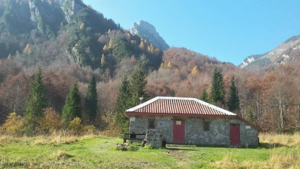
another location proposal in italy is the valley at Malga/ Casera Chiampis:
46.32708, 12.73115
Malga Chiampis is a bivac hut. i don't suggest to have the gathering in the hut, but in the huge valley floor around it. in 2018 a thousand rainbow people gathered there, it's a huge open area at 1200m ASL, surrounded by peaks just shy of 2000m ASL. the place is about 5hours hike from the road, hiking trail begins close to Tramonti di Sopra. there should be drinking water, else the rainbow gathering would not have been possible.
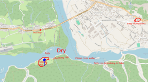
46.40129N, 12.9066E Pre Alpi Carniche, Italy
This exact spot (pin on the map) is mostly a steep hill. A vehicular dirt path runs just south of the pin, across it is plenty of brambley, flat, muddy areas. Local people do come around this area.
The pin is about a 20-30 minute hike from the road (SS52).
- Crossing a dirt path through an open field/ pasture
- then a dry river bed. The river bed is accessed from a well-used dirt ramp for offroad vehicles. The bed of the Tagliamento River itself is mostly pebbles and hikable. East of/ at the confluence "Degano" there is clean river water that is drinkable. From the vehicular bridge at Invillino, the water is no higher than knee height and probably good for bathing in the summer.
- There is another vehicular dirt ramp on the other side adjacent to an inhabited house. Next to that is a pasture that is cordoned off. Following the dirt path and turning right, the spot is just past another inhabited hut on the side of the river.
At Invillino there is a Euro Spar with super easy dumpsters. https://gopro.com/v/Bb6QmKEvLQoO9
Hitchhiking around the area is easy. A23 is accessed through Tolmezzo. There is a bus stop on SS52 No more than 30 minutes from the spot with plenty of traffic all day.
Scouting pics and videos https://gopro.com/v/zbMEae30d1eBd

