Difference between revisions of "2014 North American Hitchgathering"
| Line 33: | Line 33: | ||
==When == | ==When == | ||
| − | + | The date is tentatively set for Saturday, August 9th, with base camp being established as early as Thursday, August 7th. | |
| − | |||
| − | |||
| − | |||
| − | |||
==Discussion== | ==Discussion== | ||
Revision as of 01:50, 12 February 2014
Contents
Past Hitchgathering Info Pages
North American Gathering 2012
North American Gathering 2011
North American hitchgathering 2010
European Gatherings
Where
We have lowered it down to 4 locations. Voting is in progress. Vote on the location here.
Information on Locations
- Creelsboro Natural Bridge, Kentucky. The 7th largest natural bridge in the country. Runs over a creek that flows into the Cumberland River. Heavily wooded area. Natives and trappers/hunters used to take shelter under the bridge in storms. Hitchhiking is not easy but not difficult in the surrounding area.
Video of Creelsboro Bridge. Location on Map.
- Lake Powell, Arizona. Enormous deep lake with emerald green clear waters. Water temperature hovers around 80+ degrees in the summer. Very, very limited vegetation and no trees. Firewood would have to be brought in. Lots of rocks for cliff diving and exploring. Hitchhiking easy in the area and near a town for dumpster diving and getting food/supplies.
Video of lake. Location on map
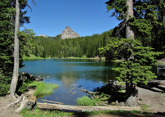
- Wind River Lake, Wyoming. Headwaters of the Wind River located on the continental divide. Can be cold in the summer. Most isolated location deep in the wilderness, but near a highway. Lots of wildlife: deer, bears, etc. Heavily forested. Hitchhiking relatively easy in surrounding area. Most gorgeous mountainous scenery of the locations. Very far from any town.
Picture of lake. Location on map.
- South Fork Yuba River, near Nevada City, California. Highway 49 bridge attracts a lot of people on summer weekends, but going a quarter mile downstream is deep water, a cave, waterfalls, cliffs for diving and rarely any people. Crystal clear water. Water temperature depends on dam activity but ranges from 73-80 degrees in the summer. Heavily forested and 10-20 foot tall boulders to hide campfires (above ground fires permitted with free permit, ground fires may need to be hidden). Probably one of the easiest places to hitchhike in the world. Easy hitch into town nearby for dumpster diving, collecting food/supplies.
Video of swimming under the boulders. Location on map.
All locations are easily accessible a short distance from the road. All locations except Wind River Lake will be warm enough for swimming. All locations should be easy to have campfires and set up a camp without being disturbed by authorities. Yuba River may be more difficult to hide campfires since it is a state park, although we managed last year without getting in trouble.
When
The date is tentatively set for Saturday, August 9th, with base camp being established as early as Thursday, August 7th.
Discussion
http://www.hitchingit.com/forums/viewtopic.php?f=29&t=21
http://reddit.com/r/hitchhiking
Can someone create a facebook event for this and link to it here?
Mailing Lists
http://lists.freeactive.net/listinfo.cgi/hitch-freeactive.net
http://lists.freeactive.net/listinfo.cgi/hitch-na-freeactive.net